Changing landscapes: The photography of OGS Crawford
Osbert Guy Stanhope Crawford (1886–1957) was one of the most influential archaeologists of the twentieth century and a pioneer in shaping archaeology into a modern and systematic discipline. Best known for his ground-breaking use of aerial photography, Crawford transformed how archaeologists understood the landscape of prehistoric Britain through the transformative Wessex from the Air, which he co-authored with Alexander Keiller. Crawford recognised that features such as earthworks, cropmarks, and ancient field systems could be seen far more clearly from above, opening entirely new avenues of research. His work revealed patterns of human activity that were invisible at ground level and established him as a central figure in the development of landscape archaeology.
Beyond his fieldwork and aerial surveys, Crawford played a major role in professionalising and sharing archaeological knowledge. As the first Archaeology Officer for the Ordnance Survey, he oversaw the systematic mapping of ancient sites across Britain and ensured that archaeological information was accurately integrated into national cartography. He also founded Antiquity in 1927, a journal that remains one of the most respected in the field. Through his publications, including Archaeology in the Field, Man and his Past, Wessex from the Air and his autobiography Said and Done, Crawford helped shape the theoretical and methodological foundations of modern archaeology. His influence continues to be felt today.
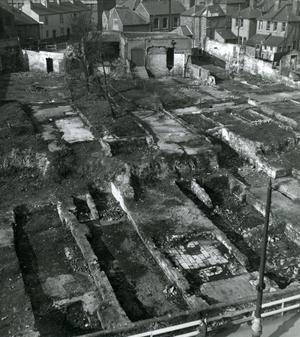
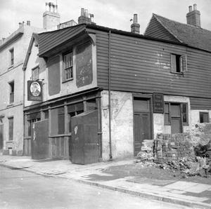
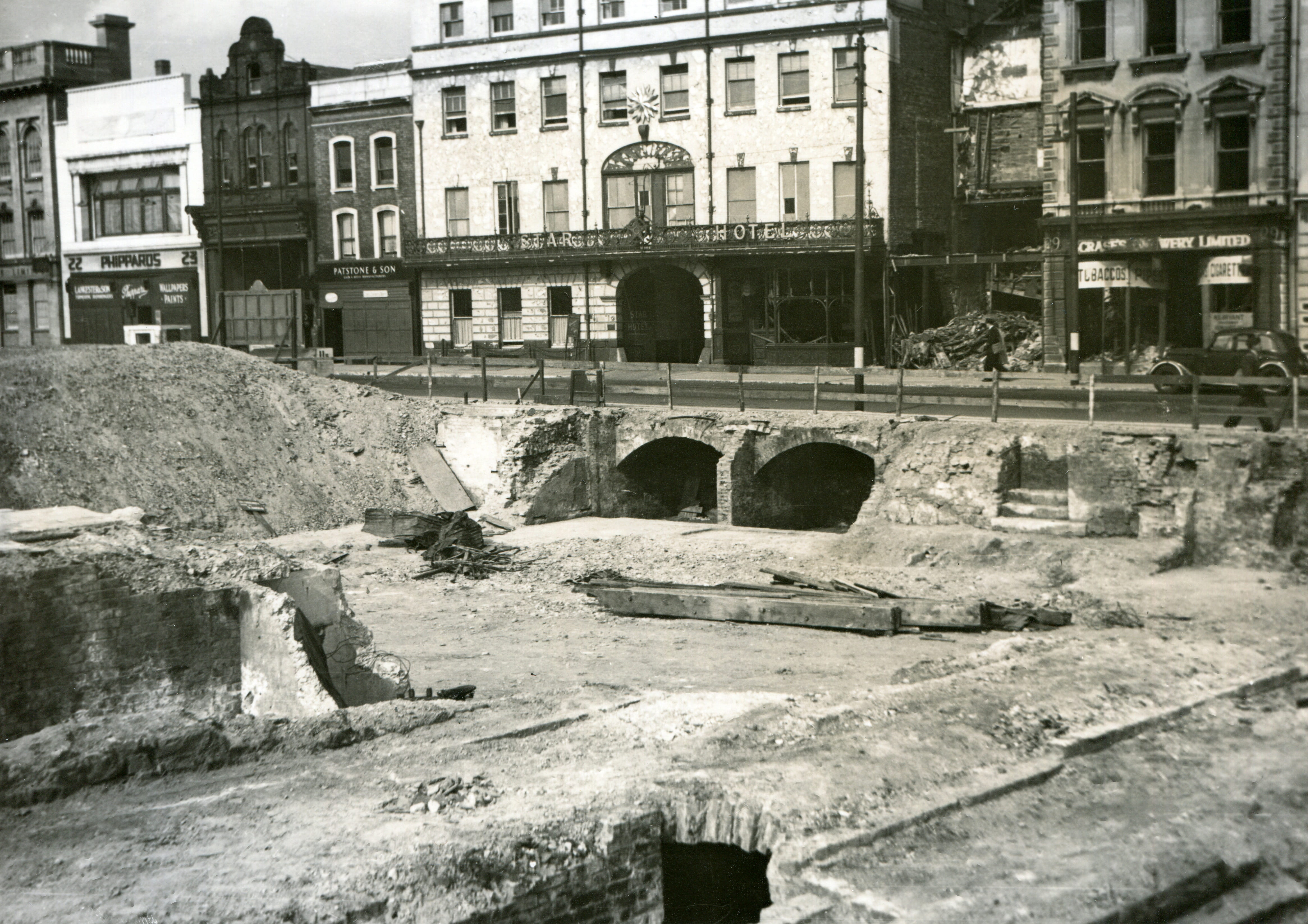
During the Second World War, the Ordnance Survey offices on London Road were destroyed on 30 November 1940 during one of the most devastating raids known as the Southampton Blitz. The dilemma of what to do with Crawford was discussed with the Treasury and he was allocated ‘for special duties during war time’. For the next five years he was seconded to work for National Buildings Record. His task was to photograph the town of Southampton to document buildings of architectural or historical interest that were at risk of being destroyed. While artwork and other treasures could be removed from major cities to safer locations, this was obviously out of the question for the town’s medieval architectural heritage. Crawford’s images revealed histories hidden in plain sight, and his photographs of Southampton record a town in transition after 45,000 buildings were destroyed.
Shown together for the first time in an exhibition opening today at Southampton City Art Gallery, these images tell the story of changing landscapes and are accompanied by Crawford’s own words, including the following extracts.
‘In 1920, I began work at the Ordnance Survey in Southampton. At first archaeology was regarded as a nuisance tacked on to the Survey as a sort of after‑thought, regarded as of no practical value, and my arrival was viewed with deep suspicion. My room contained nothing but a table and a waste‑paper basket; I had neither chair nor any clerical help. It went from a nuisance, to a harmless eccentricity, and finally became an integral part of the national record.
‘Air‑photography opened a new world. I had long been convinced that it would revolutionise field archaeology, and on March 12th, 1925, I lectured on it at the Royal Geographical Society. Soon afterwards I met Alexander Keiller, and we decided to collaborate. Keiller flew his own aeroplane and I acted as observer. With him I flew over the downs and plains of southern England, watching ancient fields, tracks and settlements emerge on the photographs like writing seen through a developing bath. Features invisible on the ground leapt out clearly from the air. It was a revelation.
‘Ancient fields appeared plainly as they had never appeared before. Crop‑marks showed us ditches and pits otherwise undetectable. Old trackways, some long suspected but never proved, became obvious at once, standing out pale against darker crops or dark against pale ones. Most striking of all were the great Celtic field systems of Wessex, invisible on the ground but perfectly clear from the air. Nothing had prepared us for the richness and variety of what was revealed.
‘Encouraged by these results we produced Wessex from the Air, published in 1928. The photographs were by Keiller and the text was mine. The book was the first of its kind in Britain showing what could be done. Our purpose was to let people see with their own eyes the ancient world revealed from above. To walk over the fields and see nothing, and then to look at the same fields from the air and see the whole plan of a settlement or cemetery standing out like a diagram, was an astonishing experience. It was like lifting a veil. The book opened people’s eyes to the possibilities of aerial archaeology and created a demand for further work.
‘The Ordnance Survey itself gradually changed, trying to get a move on was like trying to swim in a lake of glue. But on the night of 30 November 1940, the Ordnance Survey office was destroyed in the blitz, and with it my library and all my papers. It was a crushing blow. I had at first no idea where to begin, and for some time could do nothing. I had to start again from scratch and for the next five years I worked for a newly created body called the National Buildings Record, photographing buildings of architectural or historical interest. Between 1940 and 1945 I photographed 5,000–6,000 buildings, chiefly with a Rolleiflex, working under the formal direction of Alfred Clapham. Under his guidance I learnt how to read the history of a wall, and how small details, overlooked by most people, could reveal the whole story of a house. He showed me that it was often the seventeenth‑ or eighteenth‑century doorway, the altered jamb, or the half‑concealed joint in the masonry that supplied the decisive clue. He taught me to recognise the difference between a wall that had grown and a wall that had merely been built. Fieldwork in the towns had an excitement of its own. I liked to see life in the basement rather than the drawing‑room. I learnt to prefer the roots to the flowers. I learnt to see the past in the surviving fabric of the house and to read the story written in its walls.
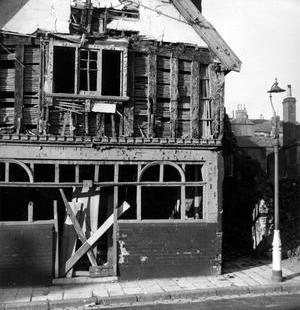
‘In Southampton, the bombing revealed interiors, thirteenth‑century cellars, and the evidence of long‑lost building lines. The cellars showed that there had been little or no alteration in the building‑line since 1200. I then investigated the documents and this made it possible to reconstruct an accurate large‑scale plan of the town as it was in the Middle Ages. The bombing had revealed things that had been hidden for centuries. My interest in Southampton led ultimately to the foundation of a society called the Friends of Old Southampton. Southampton’s post-war proposals looked to ruthlessly destroy the whole atmosphere of the historical old town by vandals. The Undercroft would be placed in the middle of a traffic island and sites like the Duke of Wellington pub would be swept off the face of the earth.
‘Looking back on my career so far as it has gone and it cannot in the nature of things go very much further, what has been accomplished? How have the ideals of youth been realised in maturity? If this were an archaeological book it would probably end up with a few general remarks which could not be fitted in elsewhere, and a set of conclusions thought to emerge from the narrative. I was taking a very great risk in deciding to adopt an archaeological career without any private means. I did it with my eyes open because I preferred to take this risk rather than spend my life doing safer but uncongenial work. I have never since then regretted my decision, but when in later years people have told me I was lucky to be doing such interesting work and to be paid for it, I do not think they realised that my successful survival as a professional archaeologist was not simply due to good luck. I did not just drop into already made positions; one, which I held for twenty‑five years at the Ordnance Survey, was made for me; and the other, the editorship of Antiquity, I made for myself. Wessex from the Air is generally regarded as my best achievement, and it certainly was quite a good effort, and a pioneer one. But it had the defects of immaturity. The Map of Roman Britain was one of my most successful pieces of work; the first edition of a thousand copies sold out at once, and more than twenty thousand were sold in later editions. When working for the National Buildings Record creating an accurate large scale plan reconstructing Southampton as it was in the Middle Ages and transcribing the 1454 Terrier was the most fascinating piece of research I have tackled for years and the only anchor left me.’