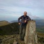
Two-hundred years ago, all across Great Britain and Ireland, the landscape was busy with surveyors occupied with measuring and mapping town and country for the Ordnance Survey. Today, the archaeological traces and legacies of these past surveying activities can still be seen 'in the field' yet remain a neglected and often overlooked aspect of our nations' heritage. In this lecture, Professor Keith Lilley (Queen's University Belfast) will talk to us about these landscapes and the associated field-monuments that played a vital role in mapping our nations. He will use examples of historic Ordnance Survey (OS) maps from Britain and from Ireland to 'excavate the map' and explore the field-evidence in our landscapes that tells a story of those who surveyed the land to make the OS maps that we all so cherish today as archaeologists. The talk is an opportunity to hear about exciting new research and community archaeology projects being led by Prof Lilley on the landscape archaeologies of the Ordnance Survey.


