A Day in the Life – Trainee Aerial Survey Investigator for Historic England
I am an Aerial Survey Investigator working as part of Historic England’s Aerial Survey Team as a level 7 apprentice. Being given the amazing opportunity to complete a Master’s degree in Archaeological Practice, alongside my career is fantastic. It is a great way of enabling a wider group of people get into a career in archaeology whilst allowing continued learning and education. When looking for a role in archaeology it was important that I found a career in an area of archaeology that I am passionate about. I always enjoyed landscape archaeology whilst I studied at university and photography is my personal hobby, but I never realised that there was a role where I could combine both. I urge anyone looking to find a career in archaeology to look at the aspects that you enjoy the most and try to get involved in as many experiences as you can, as like me you may find a career you love but don’t even know it exists!
As an Aerial Survey Investigator, the busiest time of the year for me is during the Summer months, as most of the survey flights I carry out currently focus on the discovery of new archaeological sites visible as cropmarks. See a more in-depth explanation of how cropmarks are formed in the link below. Before I can organise a survey flight, several factors decide where I should focus my survey, in the hope of choosing the best locations where cropmarks will be showing well.
On the morning before the flight, there are a lot of checks to complete. The first thing to check is the weather over the planned areas as well as the airfields I plan to take off and land at. I generally look at the wind speed, the cloud base (how high the clouds will be), the amount of cloud cover, and the visibility (sometimes in summer it can be too hazy) as these can all decide whether a flight is possible.
I also check the latest information about changes to airspace which includes any hazards to avoid or be aware of both on the way to or near my target survey areas. Some of the hazards we often encounter include gliders, active military zones, skydivers, and hot air balloons but there are many others. Then it is just a matter of making sure my kit, of which there is quite a lot, is charged up, packed, and ready to go.
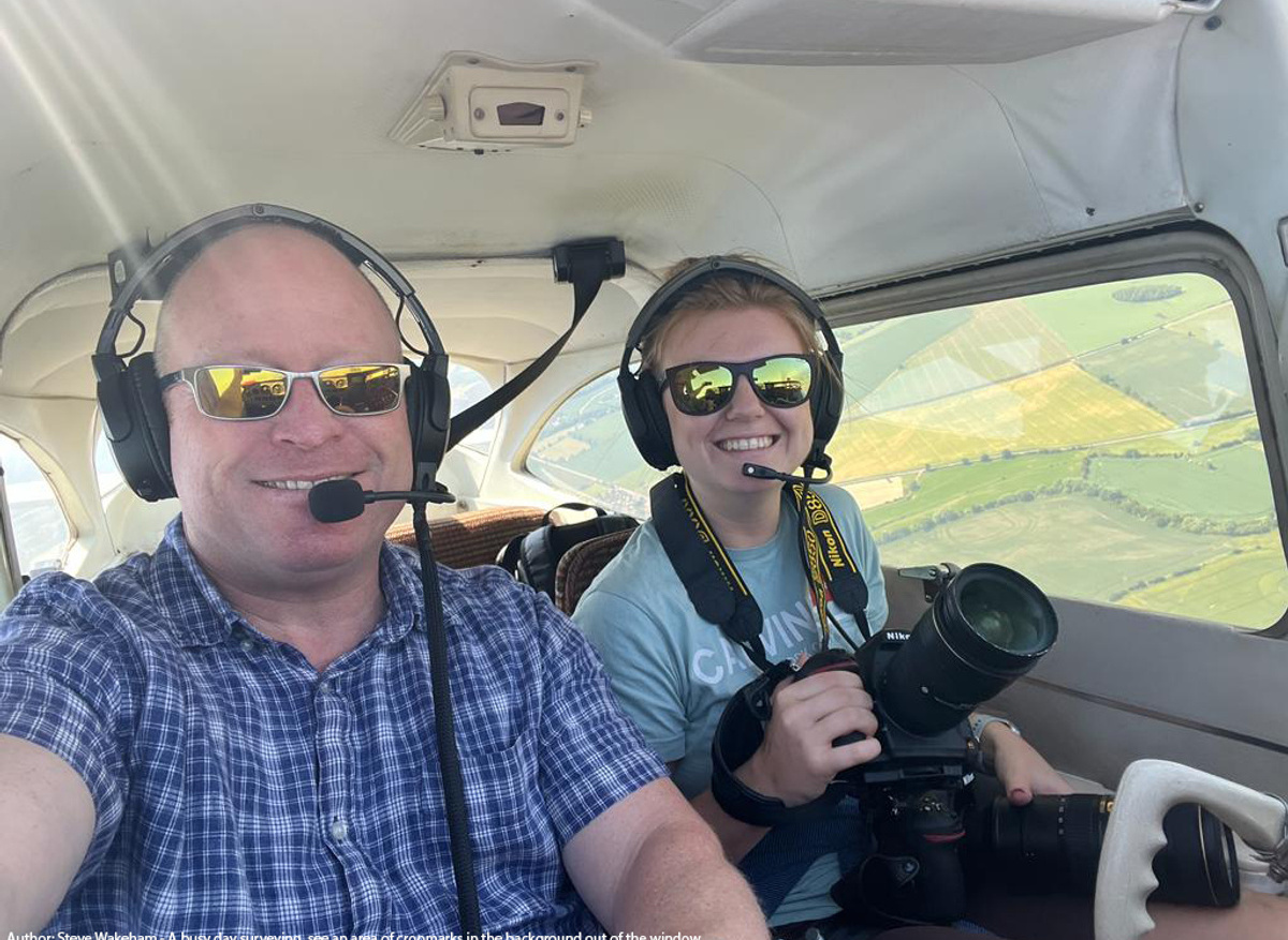
The plane that I use for surveying is a Cessna 172 which is a high-winged, light aircraft. The plane is perfect for giving me a view of the ground, although it is worth mentioning that the plane is incredibly small and feels just as small as my tiny car. The plane we use is capable of also taking vertical photographs, however I have yet to learn this and will be trained in completing vertical photograph surveys soon.
Once at the airfield, while the pilot checks that the plane is safe to fly and is fully fuelled, I check that the settings on both my cameras are set correctly for the weather conditions and level of light on the day. I must also make sure that my special tablet PC is receiving a GPS signal before I get in the aircraft. This piece of kit is very important as it tells me where we are flying over and gives me an indication of any previously recorded sites in the area.
Once everything is ready to go and checked over, we set off to the target areas. We usually fly for two to three hours which can be tiring at times as I get used to concentrating on looking for archaeology as well as directing the pilot to different locations. However, it is all worthwhile when we come across an amazing site full of fantastic features. The pilots I fly with are also extremely helpful when looking for archaeological features as, although they do not have a background in archaeology, they have a keen eye for spotting cropmarks, and have been invaluable in my first few months of training for this role.
Once a site has been identified, with archaeological cropmarks it is my responsibility to get the plane into position. I direct the pilot where to fly, which can often be challenging to judge if the wind is strong, and once the plane is in the correct position, I open the window ready to take photographs. This felt like one of the most unnatural and scary things to do on my first few flights. I photograph each target area from all sides as sometimes the appearance of the cropmarks can change vastly from one angle to another due to the position of the sun or the direction of the wind blowing the crops. I also use the long lens camera to capture any extra details, which can be useful for areas with lots of overlapping features or small features.
Each day flying can bring different challenges, but it is a fantastic opportunity to be able to get up in a plane and go looking for archaeology. I get to see historic and unique places from an angle few rarely see and every time I get airborne I see something amazing, whether it be a new archaeological site, a beautiful country house or the impressive earthwork remains of an Iron Age hillfort. My role is vital to helping develop our understanding of British archaeology with new discoveries, but it is also important to monitor and manage the sites we want to protect for the future, looking for any signs of damage or mismanagement.
There are a vast number of aerial photographs from the archive collections which can be viewed on the Aerial Photo Explorer Aerial Photograph Explorer, see the link below.